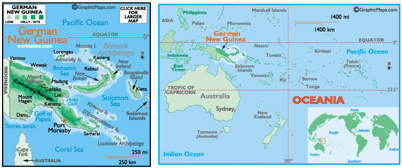
German New Guinea
(1884-1919)
|
| Capital: |
Herbertshöhe (Kokopo), Rabaul
(after 1910)
|
| Population: |
Not Available |
| Land Area: |
249,500 sq km (96,333 sq miles) |
| Land Division: |
2 Territories (Kaiser-Wilhelmsland
[Northeastern part of New Guinea]
and Bismarck Archipelago [formerly
the New Britannia Archipelago]), 2
Islands (Neu-Pommern [New Pomerania/New
Britain] and Neu-Mecklenburg [New
Ireland]), and 6 Dependencies
(German Solomon Islands [Buka,
Bougainville and several smaller
islands], the Carolines, Palau,
the Marianas [except for Guam],
the Marshall Islands, and Nauru)
|
| Currency: |
German New Guinea Mark at Par
with German Mark
|
| Languages: |
German (Official), Austronesian
Languages, Papuan Languages, German
Creoles
|
| National Day: |
None |
| Religions: |
Lutherans (European Settlers),
Indigenous Beliefs (all the rest
of the population)
|
| Ethnicity: |
Germans, various Papuan Tribes
|
|
|